Mapping What Roots Hide: How Geophysics Sees the Ground Beneath Your Trees

Trees are easy to admire above ground and easy to underestimate below it. A mature tree can extend its root system well beyond the spread of its canopy, weaving through soil, around services, and beneath paving in ways that are completely hidden from view. For most of a tree’s life this goes unnoticed. It only becomes a problem when those roots start interacting with things people care about — foundations, driveways, drainage, retaining walls, and the trees themselves during nearby construction.

That hidden interaction is exactly the kind of problem geophysics is built to solve. The same principles used to investigate soil layers and locate buried utilities can be applied to understanding root systems and the ground around them. Rather than digging exploratory trenches that damage roots and disturb the site, geophysical methods can reveal what’s happening beneath a tree non-invasively.

In this article, we’ll look at why root systems matter so much to construction and property, how geophysical techniques can map and assess the subsurface around trees, and why the best outcomes come from combining that subsurface knowledge with proper arboricultural expertise.

Why roots cause more trouble than people expect

Above ground, a tree’s needs seem simple. Below ground, the picture is far more complicated. Roots grow opportunistically, following moisture, oxygen, and the path of least resistance. That often means growing toward leaking pipes, beneath slabs where moisture collects, into the backfill around foundations, and along service trenches that offer loose, easy soil.

The consequences show up in familiar ways:

  • Lifted and cracked paving as roots thicken beneath driveways and footpaths
  • Foundation movement, particularly in reactive clay soils where roots draw out moisture and cause the ground to shrink
  • Damaged drainage and services where roots invade or displace pipes
  • Disturbed retaining structures where root growth and the soil moisture changes around it alter ground behaviour

There’s also the reverse problem. When construction happens near an established tree, excavation and ground disturbance can sever or compress critical roots, damaging or even killing a tree that was meant to be retained. In both directions — trees affecting structures and construction affecting trees — the trouble starts underground, where nobody can see it.

This is the heart of the issue. Decisions about trees, foundations, and excavation are routinely made with almost no information about what the root system is actually doing. The result is guesswork, and guesswork around mature trees is expensive in every direction: damaged structures, dead trees, failed approvals, and costly disputes.

How geophysics sees beneath a tree

Geophysical investigation offers a way to replace that guesswork with evidence, without the destructive digging that traditional root investigation often involves. Several methods are particularly relevant around trees and the ground that supports them.

Ground Penetrating Radar (GPR)

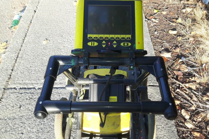
Ground Penetrating Radar is the standout tool for root investigation. GPR sends electromagnetic waves into the ground and records how they reflect off changes in material. Because roots differ from the surrounding soil in density and moisture content, larger roots can be detected and their positions mapped. This allows a non-invasive picture of where significant roots run, how deep they sit, and how they relate to nearby structures or services.

For construction planning, this is invaluable. Knowing where major roots are means excavation routes, footing positions, and service trenches can be planned to avoid the most critical parts of a root system — protecting both the tree and the structure. GPR is also widely used to locate the buried utilities that roots so often grow toward, giving a combined picture of roots and services in the same survey.

Electrical resistivity surveys

Electrical resistivity imaging maps how moisture and soil type vary across a site. Around trees, this is useful for understanding the soil environment the roots are working in — where the ground is wet or dry, where reactive clays sit, and how moisture is distributed. Since much of the structural damage attributed to trees is really about moisture-driven soil movement, understanding the moisture picture is often more revealing than looking at roots alone.

Seismic and other near-surface methods

On larger or more complex sites, seismic methods and other near-surface techniques can characterise the stiffness and layering of the ground supporting a tree or threatened by its root activity. These are particularly relevant where trees sit on or near slopes, retaining structures, or load-bearing ground, and where the interaction between roots, soil, and structure needs to be understood in more detail.

Used together, these methods turn the dark, unknowable zone beneath a tree into a mapped and understood environment — one that informs decisions rather than leaving them to chance.

Where this matters most

There are a handful of situations where understanding the subsurface around trees pays for itself many times over.

Building near established trees. When a tree is to be retained close to new construction, mapping the root system helps define realistic protection zones and design footings, services, and excavation around the roots that matter most. This protects the tree’s long-term health and avoids the unpleasant surprise of a retained tree declining after the work is done.

Diagnosing structural damage. When paving lifts, a slab cracks, or a foundation moves near a tree, the instinct is to blame the nearest roots. But the real cause might be moisture-driven clay movement, a leaking service the roots are following, or ground conditions unrelated to the tree at all. Subsurface investigation helps identify what’s actually happening before expensive remediation begins — or before a healthy tree is removed for a problem it didn’t cause.

Protecting services and infrastructure. Mapping roots alongside buried utilities helps plan repairs, replacements, and new installations in a way that avoids both damaging the services and unnecessarily cutting roots.

The benefits of investigating before acting include:

  • Non-invasive insight that protects roots rather than severing them
  • Better-informed construction around retained trees
  • Accurate diagnosis of damage rather than blame by proximity
  • Smarter service and excavation planning
  • Stronger documentation for approvals, arborist reports, and disputes

From subsurface data to the right decision

Mapping the ground beneath a tree is powerful, but it is only one half of the picture. Geophysics can tell you where roots run, how deep they go, and what the surrounding soil is doing — but interpreting what that means for the health, stability, and future of the tree itself requires arboricultural expertise. A subsurface map shows the structure of the problem; a qualified arborist understands the living system that created it and what it needs to thrive or be safely managed.

This is why the strongest outcomes come from the two disciplines working together. For property owners and projects in West Auckland, pairing reliable subsurface investigation with a qualified professional such as West Auckland Arborist means the root data is interpreted in the context of the tree’s biology, structural condition, and long-term prospects. Geophysics defines what’s beneath the surface; the arborist translates that into sound decisions about retention, protection, pruning, or removal. Together they replace guesswork with a complete, defensible understanding.

That partnership matters most on the trickier jobs — building close to significant mature trees, resolving disputes over tree-related damage, or managing trees on sites with reactive clay, slopes, or congested services. These are exactly the situations where acting on assumptions does the most harm, and where combining good subsurface data with genuine arboricultural judgement protects both the trees and the structures around them.

What a survey around trees looks like in practice

For anyone who hasn’t commissioned this kind of work before, the process is more straightforward than it sounds. A geophysical survey around trees is designed to be low-impact from start to finish — which is the whole point when the goal is to protect roots rather than disturb them.

It begins with scoping. The survey is planned around the trees of interest, the structures or services nearby, and the specific questions that need answering — whether that’s defining a root protection zone, diagnosing damage, or planning an excavation. Getting this stage right ensures the survey gathers data that actually informs the decision, rather than producing a report that looks thorough but answers the wrong question.

The fieldwork itself is non-invasive and usually quick. GPR passes and resistivity lines are run across the area using portable equipment, with no trenching, drilling, or root cutting required. On a typical residential site this can often be completed in a single short visit, with minimal disruption to the garden, paving, or the tree.

The real value comes in the interpretation. Raw data is processed and read by experienced geophysicists, who translate reflections and resistivity variations into a usable picture of root positions, soil conditions, and buried features. That interpretation is then most powerful when shared with an arborist, who can set it against the tree’s biology and condition. The combination of careful fieldwork and skilled interpretation is what turns a survey into genuinely actionable advice.

A simple decision framework

Not every tree warrants a geophysical survey, but the case for investigation strengthens quickly when several factors line up. It’s worth considering when:

  • Construction or excavation is planned close to a significant tree that must be retained
  • Paving, slabs, or foundations near a tree are showing signs of movement or cracking
  • The site has reactive clay soils prone to moisture-driven movement
  • Buried services run near established trees and need protection or repair
  • A tree-related damage claim or dispute needs to be resolved with evidence
  • Decisions about removing or retaining a valuable tree carry real cost or risk

Where several of these apply, the modest cost of a non-invasive survey is easily justified against the alternatives — damaged structures, dead trees, failed approvals, or disputes argued without evidence. Where the situation is simple and low-risk, standard arboricultural assessment may be all that’s needed. As with any investigation, the aim is to match the depth of inquiry to the level of risk.

The bigger picture

Trees and the ground they grow in form a single connected system, most of which is hidden from view. The visible canopy is only the part we notice; the roots, the soil, the moisture, and the services beneath are where most of the real interactions — and most of the real problems — actually occur. Decisions made without understanding that hidden half are decisions made half-blind.

Geophysical investigation brings that hidden half into focus. By mapping roots, revealing soil and moisture conditions, and locating buried services, it gives property owners, builders, and arborists the information they need to act with confidence rather than guesswork. And when that subsurface knowledge is combined with skilled arboricultural judgement, the result is decisions that protect trees, structures, and budgets alike.

So before excavating near a treasured tree, removing one accused of causing damage, or building close to established roots, it’s worth asking a simple question: do you actually know what’s happening beneath the surface, or are you guessing? In a field where the cost of being wrong is measured in cracked foundations and lost trees, seeing what the roots hide is one of the smartest moves you can make.
What Lies Beneath Your Driveway: The Case for Subsurface Assessment Before You Pour

A concrete driveway looks like one of the simplest things you can build. Clear the ground, lay a slab, let it cure, and you’re done. It’s just concrete, after all — strong, heavy, and seemingly indestructible. Yet anyone who has watched a relatively new driveway crack, sink, or lift within a few years knows the truth: a driveway is only ever as good as the ground beneath it.

Concrete is excellent at handling compression, but it is far less forgiving of movement. When the ground underneath shifts, settles, swells, or washes away, the slab has no choice but to follow. The cracks, steps, and dips that appear on the surface are almost always a message from below — a sign that the subsurface was not what everyone assumed it to be.

This is where geophysics becomes surprisingly relevant to something as everyday as a driveway. Subsurface investigation can reveal the ground conditions that determine whether a slab will stay flat and intact or begin failing the moment the first heavy load rolls across it. In this article, we’ll explore why driveways fail from the ground up, what geophysical assessment can reveal, and how that knowledge leads to a driveway that lasts.

Why driveways fail from below

When a driveway cracks or settles, the instinct is to blame the concrete — poor mix, insufficient thickness, or bad workmanship. Those factors certainly matter. But in a great many cases, the concrete did exactly what it was supposed to do, and the ground let it down.

The most common subsurface causes of driveway failure include:

  • Poorly compacted or uncontrolled fill, which settles unevenly over time
  • Reactive clay soils that swell when wet and shrink when dry, lifting and dropping the slab through the seasons
  • Voids or soft pockets beneath the surface that offer no real support
  • Poor drainage and trapped water, which softens the ground and erodes fine material away
  • Buried organic material or debris that decomposes and collapses
  • Old, undocumented services or backfilled trenches that compact differently from the surrounding ground

Each of these conditions shares one frustrating trait: it is invisible from the surface. A site can be graded flat, look firm, and feel solid underfoot while concealing a soft layer, a buried void, or an expansive clay that only reveals itself once the seasons turn. By the time the symptoms appear in the concrete, the cause has been quietly at work for months or years.

The hidden cost of guessing

Replacing or repairing a failed driveway is expensive, disruptive, and avoidable. Breaking out cracked concrete, re-preparing the ground, and re-pouring is far more costly than getting the preparation right the first time. Worse, if the underlying ground problem isn’t identified and addressed, the replacement slab will often fail the same way the original did — leading to repeated repairs and mounting frustration.

The fundamental issue is that ground preparation is frequently based on assumption rather than information. The ground is graded and compacted to look right, but nobody truly knows what’s underneath the working surface. That gap between what’s assumed and what’s real is where most driveway failures are born.

Geophysical investigation closes that gap by replacing assumptions with evidence.

What geophysical assessment can reveal

Geophysical surveys are non-invasive, meaning they gather detailed information about the subsurface without the need to dig it all up first. For driveway and hardstand projects, a small number of techniques are especially useful.

Ground Penetrating Radar (GPR)

Ground Penetrating Radar is one of the most directly applicable tools for driveway projects. GPR uses electromagnetic waves to image the shallow subsurface, producing a detailed picture of what lies just below the working surface. It can detect voids, locate buried services and old footings, identify backfilled trenches, and reveal changes in material that might cause uneven support.

GPR is also valuable for existing concrete. If you’re assessing a slab before resurfacing or building on top of it, GPR can scan for thickness, reinforcement, voids beneath the slab, and signs of subsurface erosion. Because dry, sandy soils tend to give particularly clear results, GPR is well suited to many driveway environments.

Electrical resistivity surveys

Electrical resistivity imaging maps how moisture and soil type vary across a site. For a driveway, this is invaluable for identifying where water concentrates and where reactive or saturated soils sit. Since water and reactive clays are two of the biggest drivers of slab movement, knowing where they are allows the ground preparation and drainage to be targeted exactly where it’s needed.

Seismic methods

For larger or more critical hardstand and pavement projects, seismic refraction and MASW can measure the stiffness and strength of the ground, confirming whether it can carry the intended loads. While a residential driveway may not always warrant this level of investigation, larger driveways, commercial hardstands, and heavily loaded surfaces benefit from this quantitative strength data.

Together, these methods turn an unknown patch of ground into a mapped, understood foundation — one you can prepare for with confidence rather than crossing your fingers.

How investigation leads to a better driveway

The point of a subsurface assessment is to inform the decisions that actually determine longevity. With good ground information in hand, the preparation can be tailored to the real conditions:

  • Soft pockets and voids can be identified and properly addressed before pouring
  • Reactive clay zones can be managed with appropriate sub-base and moisture control
  • Drainage can be designed where water actually collects rather than where it’s assumed to
  • Slab thickness and reinforcement can be matched to the support the ground can offer
  • Buried services and trenches can be located and accounted for, avoiding both damage and weak spots

The result is a driveway built on understanding rather than hope. Instead of discovering the ground’s quirks the hard way — through cracks and settlement — they’re known in advance and designed around. That is the difference between a slab that holds its line for decades and one that starts moving within a season or two.

From assessment to a finished driveway

Knowing what’s beneath the surface is essential, but it’s only the starting point. Once the ground has been investigated and the conditions are understood, the driveway still has to be prepared, formed, and poured by people who know how to turn that information into a durable result. Even the most thorough subsurface assessment won’t help if the sub-base preparation, reinforcement, mix, and finishing aren’t handled with care.

This is where good information and good workmanship come together. For property owners in Perth who want to act on solid ground data and have the job done to a high standard, experienced concreting specialists such as Perth Concrete Driveway can take the subsurface findings into account and deliver a driveway built for the conditions on site. Combining a proper understanding of the ground with skilled construction is the most reliable way to get a driveway that stays flat, intact, and trouble-free for the long haul.

That combination matters most on tricky sites — properties with reactive clay, areas of fill from past landscaping, blocks with drainage challenges, or sites where the ground has been disturbed by earlier works. These are exactly the conditions where guessing is most likely to go wrong, and where the pairing of reliable assessment with experienced workmanship delivers the greatest return.

Fitting the assessment into your project timeline

One concern property owners often raise is timing — they worry that a subsurface assessment will add weeks of delay to a project they’d rather just get moving on. In reality, geophysical investigation fits neatly into the early planning phase and rarely holds anything up.

The ideal moment to investigate is before the ground is prepared and certainly before any concrete is ordered. At that stage, the findings can still influence every decision that follows: how the sub-base is built up, where drainage is run, how thick the slab needs to be, and whether any soft zones need treatment. Investigating after the preparation is finished is far less useful, because the decisions the data should have informed have already been made.

Fieldwork itself is typically fast and non-disruptive. For a residential driveway, the survey can often be carried out in a single short visit using portable equipment, with no need to excavate or drill the site beforehand. The interpretation and reporting that follow give you a clear understanding of the ground in days rather than weeks.

When you line this up against the timeline of a failed driveway — breaking out concrete, diagnosing the cause after the fact, re-preparing the ground, and pouring again — the small amount of time spent investigating up front looks like exactly what it is: an efficient way to avoid a far longer and more expensive detour later.

A simple decision framework

Not every driveway needs a full geophysical survey, but a little judgement goes a long way. Investigation becomes increasingly worthwhile when:

  • The site has a history of fill, demolition, or earthworks
  • The soil is known or suspected to be reactive clay
  • The driveway will carry heavy or repeated loads
  • There have been drainage or settlement problems nearby
  • A previous driveway on the site cracked or sank
  • Buried services may run beneath the proposed slab

If several of these apply, the small upfront cost of a subsurface assessment is easily justified by the much larger cost of premature failure. If none apply and the ground is well understood, standard preparation may be perfectly adequate. The goal isn’t to over-investigate every project — it’s to match the level of investigation to the level of risk.

The bigger picture

A driveway is a deceptively simple structure that depends entirely on something complicated and hidden: the ground beneath it. Concrete gets the attention, but soil, moisture, fill, and voids do most of the deciding. The driveways that last are the ones built on a real understanding of those conditions, and the ones that fail are almost always built on assumptions that turned out to be wrong.

Geophysical investigation offers a practical, non-invasive way to replace those assumptions with evidence. By imaging the shallow subsurface, mapping moisture and soil variation, and locating voids and buried features, it gives you the knowledge to prepare the ground properly and pour with confidence. In a project where redoing the work costs far more than getting it right the first time, that knowledge is one of the most cost-effective steps you can take.

So before the formwork goes up and the truck arrives, it’s worth asking a simple question: do you actually know what’s beneath your driveway, or are you hoping for the best? Understanding the ground first is the quiet decision that separates a driveway you forget about from one you keep paying to fix.

Geophysics and Retaining Walls: Why the Ground Decides Everything

A retaining wall is one of those structures people only think about when something goes wrong. When it works, it disappears into the landscape — holding back soil, shaping usable land, and quietly doing its job for decades. When it fails, the consequences are rarely subtle: bulging masonry, cracked render, tilting panels, slumped garden beds, and in the worst cases, a full collapse that takes part of the slope with it.

Here’s the part that surprises many property owners. When a retaining wall fails, the wall itself is usually not the original problem. The wall is the symptom. The real cause almost always lies in the ground behind it and beneath it — the very thing nobody could see when the project began. Unstable soil, unexpected groundwater, a hidden weak layer, or a poorly understood slope can defeat even a well-built wall.

This is precisely where geophysics earns its place in the conversation. Before a single block is laid or a single footing is poured, geophysical investigation can reveal what the ground is actually doing. In this article, we’ll look at why subsurface conditions govern retaining wall performance, what geophysical methods can tell you, and how that information protects both your budget and your safety.

Why retaining walls are really a ground problem

A retaining wall exists to resist lateral earth pressure — the sideways force that soil exerts as it tries to find its natural angle of repose. That force is not a fixed number. It changes depending on the type of soil, how much water it holds, how it is layered, and what sits on top of it.

Two walls of identical design can behave completely differently depending on the ground they’re built into. A wall founded on dense, well-drained material behaves predictably. A wall founded on soft clay, loose fill, or a saturated zone behaves like a structure built on a moving target. The design might be textbook-perfect, but if the assumptions about the ground were wrong, the outcome will be too.

The most common contributors to retaining wall distress include:

  • Soft or compressible soils that settle unevenly under load
  • Groundwater and poor drainage, which dramatically increase pressure behind the wall
  • Uncontrolled or undocumented fill, often left over from previous earthworks
  • Weak layers or planes within an otherwise stable-looking slope
  • Variable depth to bedrock, which affects how footings should be founded

The trouble is that none of these conditions are visible from the surface. A site can look perfectly ordinary — flat, dry, firm underfoot — and still conceal a soft layer two metres down or a perched water table that only appears after heavy rain. Relying on appearances is how expensive surprises happen.

What geophysical investigation reveals

Geophysical surveys provide a non-invasive way to understand subsurface conditions before design decisions are locked in. Rather than relying on a handful of widely spaced boreholes — which only sample tiny points and can miss what lies between them — geophysics produces a continuous picture of the ground across the whole footprint of interest.

For retaining wall and slope projects, several methods are particularly valuable.

Electrical resistivity surveys

Electrical resistivity imaging works by measuring how easily electrical current passes through the ground. Because different materials conduct electricity differently, this method is excellent at distinguishing between dry and saturated zones, mapping soil layers, and locating groundwater. For a retaining wall, knowing where water concentrates is critical — water is one of the single biggest drivers of wall failure, and a resistivity survey can highlight the zones most at risk well before construction.

Seismic refraction and MASW

Seismic refraction and Multichannel Analysis of Surface Waves (MASW) use the behaviour of seismic waves to measure the stiffness and strength of subsurface materials. These techniques are ideal for determining depth to bedrock, identifying soft or weak layers, and assessing how competent the ground is for founding a structure. The data they produce is quantitative, meaning engineers can feed real velocity and stiffness values directly into their design calculations rather than relying on assumptions.

Ground Penetrating Radar (GPR)

Ground Penetrating Radar provides high-resolution imaging of the shallow subsurface. For retaining wall projects, GPR is useful for detecting buried obstructions, voids, old footings, services, and changes in material near the surface. Because excavation around retaining walls is often shallow but congested, knowing what’s there in advance prevents both damage and delay.

Used together, these methods complement one another. Resistivity finds the water and maps the layers, seismic methods measure the strength, and GPR fills in the near-surface detail. The result is a far more complete understanding than any single technique can offer on its own.

How this information protects a project

The value of a geophysical survey is not the data itself — it’s the decisions the data makes possible. When designers understand the ground, they can specify the right wall type, the right footing depth, and the right drainage strategy from the outset. When they don’t, they’re forced to either over-engineer (which wastes money) or under-engineer (which risks failure).

Consider a sloping site where a resistivity survey reveals a saturated zone feeding water toward the proposed wall line. With that knowledge, the design can incorporate proper subsurface drainage, weep holes, and a wall type suited to high water pressure. Without it, the wall might be built to resist dry-soil pressures it will never actually experience — and fail within a few wet seasons.

Or consider a site where seismic data shows bedrock at a shallow but uneven depth. That single piece of information can change everything about how footings are designed and founded, potentially saving a fortune in remediation later. These are not exotic scenarios; they are everyday situations where a modest upfront investigation prevents a major downstream cost.

The benefits of investigating before building include:

  • Right-sized design that neither wastes money nor cuts corners
  • Targeted drainage based on where water actually sits
  • Fewer surprises during excavation and construction
  • Reduced risk of settlement, tilting, and long-term failure
  • Stronger documentation for approvals and compliance

From investigation to construction

Understanding the ground is the foundation — but it’s only half the story. Once a geophysical survey has mapped the subsurface and the design has been shaped around real conditions, the work has to be built by people who know how to translate that design into a durable structure. A perfect investigation paired with poor construction still ends badly, and the reverse is equally true: skilled builders working blind to the ground conditions are gambling with the outcome.

This is why the best results come from the two halves working together. For property owners on the Gold Coast looking to act on solid subsurface information and have a wall built properly, experienced specialists such as Gold Coast Retaining Wall can take the ground data into account and deliver a wall designed for the conditions that actually exist on site. Pairing reliable subsurface investigation with experienced construction is the surest path to a retaining wall that performs for the long term rather than one that needs repair within a few years.

That partnership matters most on challenging sites — steep slopes, reactive clays, high water tables, or properties where previous earthworks have left the ground in an unknown state. These are exactly the situations where guessing is most expensive, and where combining good data with good workmanship pays for itself many times over.

What a retaining wall survey looks like in practice

For property owners who have never commissioned a geophysical survey, the process can sound more complicated than it is. In practice, a typical investigation for a retaining wall or slope project follows a straightforward sequence.

It begins with a site assessment, where the survey is scoped around the proposed wall alignment, the slope above and below it, and any areas of known concern. This planning stage matters, because the right survey lines and the right combination of methods make the difference between data that answers the design questions and data that merely fills a report.

Fieldwork is usually non-invasive and surprisingly quick. Resistivity lines, seismic spreads, or GPR passes are laid out across the area of interest, and measurements are collected with portable equipment. There is no need to tear up the site or drill it full of holes, which means the investigation can often be completed in a single visit with minimal disruption.

The real value, though, comes after the fieldwork. Raw data is processed and interpreted by experienced geophysicists who translate it into something a designer can actually use — a picture of soil layers, water zones, depth to competent ground, and any anomalies that warrant attention. That interpretation, not the raw readings, is what protects the project. It’s also why experience matters so much: the same dataset can tell very different stories depending on how skilfully it’s read.

Common mistakes worth avoiding

Over the years, a familiar set of avoidable mistakes shows up again and again on retaining wall projects:

Skipping investigation to save money. The cost of a subsurface survey is almost always a small fraction of the cost of remediating a failed wall. Treating investigation as optional is a false economy.

Assuming nearby conditions apply. Ground conditions can change dramatically over short distances. What a neighbour found on their block is not a reliable guide to yours.

Ignoring water. Drainage is the single most under-appreciated factor in retaining wall performance. Many failures trace directly back to water pressure that was never accounted for.

Treating the wall as a standalone object. A retaining wall is part of a system that includes the slope, the soil, the drainage, and the loads above it. Designing the wall without understanding that system is designing half a solution.

The bigger picture

Retaining walls sit at the intersection of geology, hydrology, and engineering. They are asked to hold back forces that are invisible, variable, and easy to underestimate. The structures that succeed are the ones built on genuine understanding of the ground — and the ones that fail are almost always the ones built on assumptions.

Geophysical investigation turns those assumptions into information. By mapping soil layers, locating groundwater, measuring strength, and revealing hidden features, it gives designers and builders the knowledge they need to get the wall right the first time. In a field where remediation is far more expensive than prevention, that knowledge is one of the smartest investments a project can make.

If you’re planning a retaining wall — particularly on a sloping, wet, or previously disturbed site — the question isn’t whether you can afford to investigate the ground first. It’s whether you can afford not to. Understanding what lies beneath is the difference between a wall that quietly does its job for decades and one that becomes a costly problem you’ll be revisiting far sooner than you’d like.

Utility Detection & Mapping: Preventing Costly Mistakes Before They Happen

Before any excavation or construction begins, one of the most critical steps is identifying what lies underground. Utility detection and mapping services provide a clear and accurate understanding of buried infrastructure, helping prevent costly damage, delays, and safety hazards.

Underground utilities are often more complex than they appear on records or drawings. Over time, changes, repairs, and undocumented installations can create discrepancies between plans and reality. This makes reliable detection essential for any project involving ground disturbance.

Modern utility detection combines multiple technologies, including Ground Penetrating Radar (GPR) and electromagnetic locators, to identify and map subsurface utilities with precision.

These services are essential for:

  • Locating water, gas, and sewer lines
  • Identifying electrical and communication cables
  • Mapping unknown or undocumented utilities
  • Supporting safe excavation and construction planning

One of the biggest risks in construction is striking a buried utility. This can lead to project delays, expensive repairs, and serious safety incidents. By conducting thorough detection and mapping before work begins, these risks can be significantly reduced.

Accurate mapping also improves project efficiency. When teams know exactly where utilities are located, they can plan excavation routes, avoid conflicts, and work more confidently. This leads to smoother workflows and fewer unexpected issues.

Utility detection is particularly important in urban environments, where infrastructure is dense and often layered. In these settings, precision is critical, and advanced techniques are necessary to distinguish between different types of utilities.

Key benefits include:

  • Reduced risk of damage and service interruptions
  • Improved safety for workers and the public
  • Better project planning and coordination
  • Compliance with regulations and industry standards

Ultimately, utility detection and mapping are about protecting both your project and the people involved. With accurate subsurface information, you can move forward with confidence, knowing that potential hazards have been identified and addressed.

Seismic Refraction & MASW: Measuring Strength Beneath the Surface

Understanding the strength and composition of subsurface materials is essential for any construction or engineering project. Seismic refraction and Multichannel Analysis of Surface Waves (MASW) are two powerful geophysical methods used to evaluate these properties with precision and reliability.

Both techniques rely on the behaviour of seismic waves as they travel through the ground. By generating controlled vibrations and measuring how waves move through different materials, geophysicists can determine the stiffness, density, and layering of subsurface structures.

Seismic refraction focuses on how waves refract, or bend, as they pass through materials with varying velocities. MASW, on the other hand, analyses surface waves to estimate shear wave velocity — a key indicator of soil stiffness and strength.

These methods are widely used in construction, infrastructure development, and geotechnical engineering. They provide critical data that helps ensure structures are built on stable and suitable ground conditions.

Common applications include:

  • Evaluating soil and rock strength for foundation design
  • Determining depth to bedrock
  • Assessing site suitability for construction projects
  • Supporting seismic hazard analysis and risk assessment

One of the biggest advantages of seismic methods is their ability to provide quantitative data. Unlike some techniques that offer general indications, seismic surveys deliver measurable values that engineers can use directly in design calculations.

Another benefit is their depth capability. Seismic refraction and MASW can investigate deeper layers than many other geophysical methods, making them ideal for large-scale or complex projects.

However, like all geophysical techniques, accuracy depends on proper execution and interpretation. Factors such as ground conditions, noise, and equipment setup can influence results. This is why experienced professionals are essential to ensure reliable outcomes.

In today’s construction environment, where safety and precision are paramount, seismic refraction and MASW offer invaluable insights. By understanding what lies beneath the surface, project teams can design with confidence and reduce the risk of structural issues.

Electrical Resistivity Surveys: Understanding What Lies Beneath

Electrical resistivity surveys are a cornerstone of geophysical investigation, offering valuable insights into soil composition, groundwater presence, and subsurface structures. By measuring how electrical currents flow through the ground, this method provides a detailed picture of underground conditions without the need for excavation.

The principle behind resistivity surveys is simple: different materials conduct electricity differently. For example, water-saturated soils typically have lower resistivity, while dry or rocky materials tend to have higher resistivity. By analysing these variations, geophysicists can interpret subsurface layers and identify important features.

This technique is widely used in environmental studies, construction planning, and groundwater exploration. It is especially useful when understanding soil stability or identifying potential hazards beneath a site.

Electrical resistivity surveys are commonly used for:

  • Mapping subsurface soil layers and geological formations
  • Locating groundwater resources and aquifers
  • Detecting contamination zones or landfill boundaries
  • Assessing soil conditions for construction projects

One of the key advantages of resistivity surveys is their ability to cover large areas efficiently. With the right equipment and setup, technicians can collect data across wide sites and generate detailed subsurface profiles. This makes it an ideal choice for projects that require a broader understanding of underground conditions.

Another important benefit is its adaptability. Electrical resistivity can be applied in various environments, from open land to urban developments, and can be tailored to different depths and resolutions depending on project needs.

Despite its effectiveness, proper data interpretation is essential. The results of a resistivity survey are not always straightforward and require experienced analysis to accurately identify subsurface features. Factors such as soil moisture, temperature, and mineral content can influence readings, making expertise a critical component of the process.

In practical terms, electrical resistivity surveys help project teams make better decisions. Whether determining the best location for foundations, identifying groundwater sources, or assessing environmental risks, this method provides reliable data that supports planning and design.

As infrastructure and environmental demands continue to grow, electrical resistivity remains a trusted and versatile solution for subsurface investigation.

Ground Penetrating Radar (GPR): A Modern Solution for Subsurface Detection

Ground Penetrating Radar (GPR) has become one of the most valuable tools in modern geophysics, offering a non-invasive and highly accurate way to investigate what lies beneath the surface. Whether you’re planning construction, assessing infrastructure, or avoiding underground hazards, GPR provides real-time insights that help reduce risk and improve decision-making.

At its core, GPR uses electromagnetic waves to scan the ground and detect variations in subsurface materials. These signals bounce back to the surface when they encounter different structures, allowing technicians to interpret and map what’s below without excavation. This makes it especially useful in urban environments where digging can be costly, disruptive, and dangerous.

One of the primary advantages of GPR is its ability to locate underground utilities. In many projects, knowing the exact position of pipes, cables, and conduits is critical to avoiding damage and delays. GPR helps identify these features quickly and accurately, even in complex or congested subsurface conditions.

GPR is commonly used for:

  • Locating buried utilities such as water lines, gas pipes, and electrical cables
  • Detecting voids, sinkholes, and subsurface anomalies
  • Scanning concrete structures for rebar, post-tension cables, and thickness
  • Identifying buried objects or archaeological features

Another key benefit of GPR is its high-resolution imaging. Unlike traditional methods that may provide limited or indirect data, GPR produces detailed visual representations of subsurface features. This allows engineers and project managers to make more informed decisions based on clear and reliable information.

However, the effectiveness of GPR depends on several factors, including soil conditions and material composition. For example, dry sandy soils tend to produce better results, while clay-rich or highly conductive soils may reduce signal penetration. This is why experienced operators and proper interpretation are essential for accurate outcomes.

In construction and engineering projects, GPR plays a crucial role in pre-construction planning. By identifying potential obstacles early, teams can adjust designs, avoid costly rework, and ensure safer excavation processes. This proactive approach not only saves time but also significantly reduces project risks.

Ultimately, Ground Penetrating Radar is a powerful tool that combines speed, accuracy, and non-invasive testing. As technology continues to advance, GPR remains at the forefront of subsurface investigation, helping professionals uncover hidden conditions and move forward with confidence.

© 2026 SMNG Geophysics

Theme by Anders NorenUp ↑